The new political map of Britain correlates with the locations of the country’s coalfields
Britons can now drive from Land’s End to Scotland without leaving a Conservative constituency but what is truly fascinating about the new political map of Britain is that it correlates to the locations of our country’s coalfields.
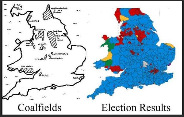
Contrasted in an image shared on Facebook by Nick Cookson, these two maps illustrate that constituencies that elected Labour outside of London mostly coincide with the coalfields of such places as East Lancashire, Northumberland and South Wales. The rest of the country is lit up blue.
Two stories to keep beside you

Margaret Thatcher: Strong lady, weak men
Author Sarah Tucker shares her thoughts on the reaction to the death of Margaret Thatcher I can’t really remember much about when Maggie Thatcher was in power. I know my parents were full of praise for her because our country was almost third world when she became PM, strikes crippling industries, rubbish being left […]

Mr Gus Instinct on UKIP’s success in this week’s elections
Billericay here we come The future political landscape of Britain has been subverted by the most meaningless political party in our history
The legacy of mining lives on despite the decimation of that industry by Margaret Thatcher in the 1980s and as Tony Blair and Lord Mandelson warned yesterday, if Labour is to have any chance of avoiding a decade in exile, they must accept that they ought to be talking to a wider audience.
Subscribe to our free once daily email newsletter here:[contact-form-7 id=”225″ title=”Contact form 1″]

Readers have their say
2 comments
The left’s narrative is that Mrs Thatcher destroyed Britain’s industry. Of course she didn’t. It was globalisation, destructive unions with a perspective of approximately six inches, a rubbish education system for most people and a snobbish disdain for industry among the wealthy, the well-educated and the media.
Another of Martin’s boring stories
My grandfather and great grand father – like me – were capitalist lackeys; but in a rather better way
My great grandfather was the private Physician to Lord Penrhyn, who owed the enormous slate ‘ mine / quarry ‘ near Bangor in north Wales
His son – my mother’s father – was the private Physician to the Tredegar family near Newport, Monmouthshire during the Edwardian period, the teens, twenties and early thirties
The Tredegars owned much of the local mining infrastructure and the coal exporting structure………my grandfather had a ‘ panel ‘ of three thousand miners as a balance…….some balance, as Welsh anthracite fuelled the navies of the world
Coal was the industry of the time that made these places just like the oil producers of today
The collieries were nationalised in 1946 and later ostracised by all then snuffed out by Margaret Thatcher
Of course these people’s bread earners were ‘ emasculated’, sore and look to Old Labour for their salvation, but they are more likely to be regenerated through the forthcoming Cameron miracle than the indignity of benefits
These people now know that Mandelson, having eschewed them, is not going to support their cause and Ed is’ histoire ‘